
The East River flows between the New York Harbor and Long Island Sound. This river identifies the borders of Manhattan, Queens and Brooklyn. Ferries, sightseeing cruises, and some commercial vessels frequently navigate this waterway. Roosevelt Island is perhaps the most notable feature that’s situated in the heart of the East River.
Geography and Features
The East River meets the New York Harbor near Governor’s Island, which is an island that’s home to historic forts and other recreational amenities. This waterway defines Manhattan’s eastern borders between the Financial District and the Upper East Side.
The South Street Seaport is perhaps the most famous attraction that’s located at the southern end of the river. This historic district includes shopping plazas, museums, and several traditional vessels that have been fully restored.
Located in Midtown Manhattan, the headquarters of the United Nations rises hundreds of feet above the East River. Roosevelt Island is situated just north of this massive office complex. The southern tip of the island includes the Franklin D. Roosevelt Four Points Park, which offers panoramic views of Manhattan’s skyline. Most of the island is occupied by residential buildings and some recreational facilities. The northern part of Roosevelt Island includes a small park with a restored lighthouse that stands as a historical marker.
The East River diverts away from Manhattan near Randalls Island, which is home to some of the largest sports facilities in New York City. Additionally, the river flows past Rikers Island, which has been home to the city’s biggest prison campus for generations. The northeastern end of the waterway connects to the Long Island Sound. Some of Westchester County’s wealthiest communities have direct access to this quiet and scenic sound that flows into the Atlantic Ocean.
Transportation
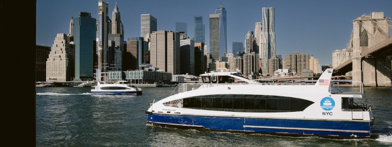
The fastest and cheapest way to navigate the East River is on a ferry that’s open to the public. The NYC Ferry network consists of multiple routes that connect Manhattan with Brooklyn and Queens. Most of the services cater to commuters during the rush morning and evening hours. However, visitors are more than welcome to hop on these express ferries that stop near some of the most popular attractions in The Big Apple.
For example, the East 34th Street Terminal is conveniently located near Midtown Manhattan. The Wall Street dock is only steps away from the bustling Financial District in Lower Manhattan. Long Island City is a thriving neighborhood in Queens that has ferry stops. In Brooklyn, the DUMBO and Williamsburg districts are also served by the NYC Ferry system.
If you’re looking to get across the East River by car, you have several convenient options. Built in the late 19th century, the Brooklyn Bridge is perhaps the most iconic structure that stands above this waterway. The Manhattan Bridge and Williamsburg Bridge also link Manhattan with Brooklyn. Running between Midtown Manhattan and Queens, the Queensboro Bridge is another busy bridge that’s situated over the East River. Despite standing above Roosevelt Island, the bridge doesn’t actually have any exits to the island. Nevertheless, you can take the Roosevelt Island Tramway between the island and Manhattan. This aerial tramway offers amazing views of the surroundings from hundreds of feet above the water.
History
The East River provided important navigational routes for Dutch colonists in the 17th century. British forces also used this river to expand their influence in the New York area. During the American Revolution, the Continental Army took advantage of the river and earned some major victories against the enemies. Subsequently, the East River sparked tremendous commercial growth in the maritime industry of New York City. Today, this channel between Manhattan and Queens isn’t heavily used for commercial or recreational operations.